mono Pilgrimage Guide to Kofu and Yamanashi, Japan
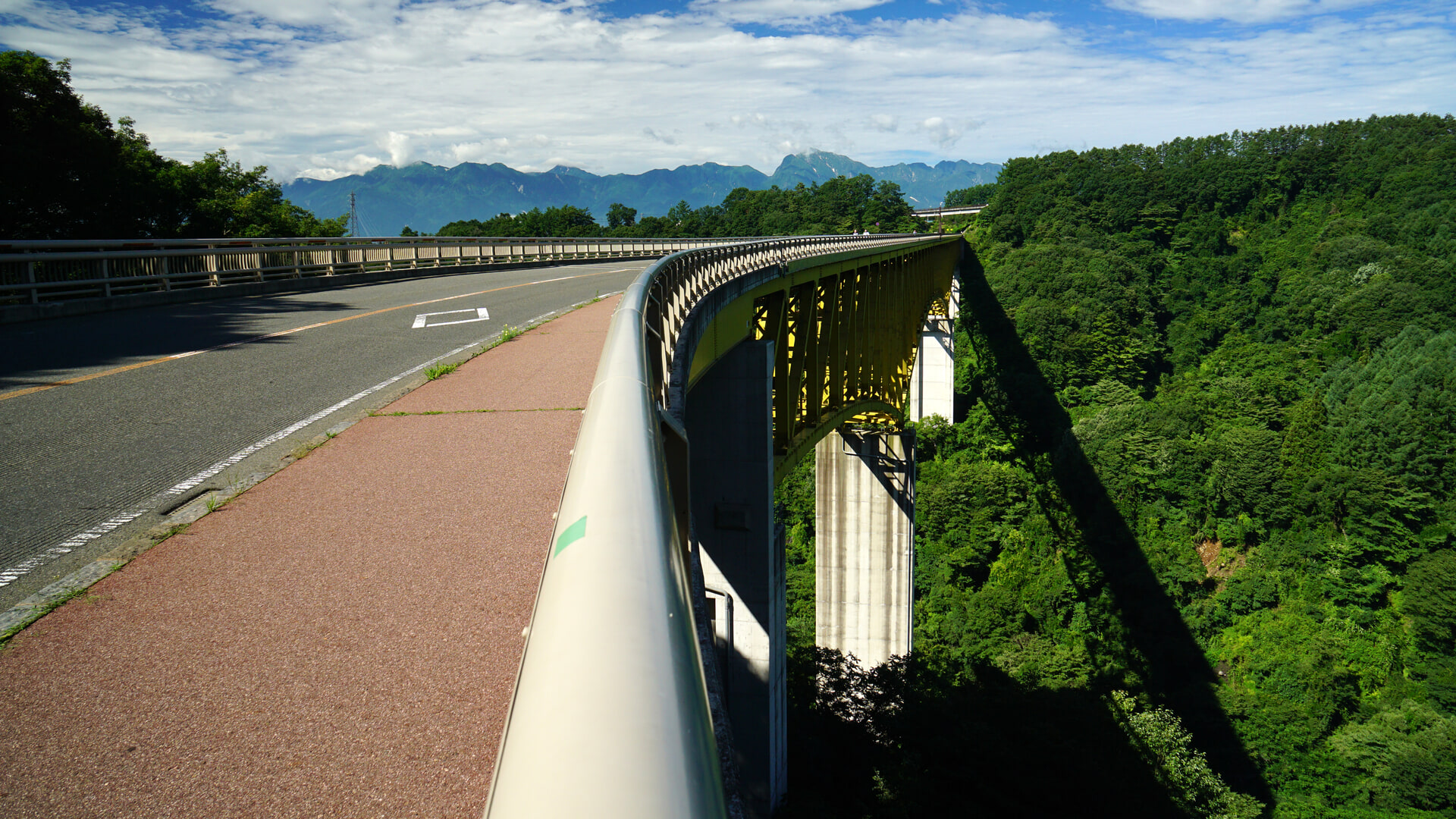
Header photo: the Yatsugatake Kogen Ohashi bridge in Hokuto, location 07 on the official map and described there as a photo spot, looking towards the Southern Alps. Photographed in 2015. Photo: 663highland, CC BY 2.5 (cropped and resized). Source.
The places in mono are ordinary on purpose: a station forecourt, a public library, a red bridge over a gorge, a grape stall, a bath that opens an hour before sunrise. The local authorities understood this quickly. Kennou Net Yamanashi, a tourism partnership of nine cities and three towns around the Kofu basin whose secretariat sits inside Kofu City’s own tourism division, has mapped fifty-three locations from the series across ten of those municipalities, printed a pilgrimage map and published a digital one. In February 2026 the area was selected as an Anime Seichi 88 pilgrimage site for the series by the Anime Tourism Association. Fifty-three places is a map, not a day: choose one district — Kofu on foot, the fruit and hot-spring hills, the vineyards, or the Kiyosato plateau — and keep the official map for the rest. This guide picks routes; the map holds every spot.
Quick Trip Guide
- Destination: the Kofu basin and the Yatsugatake foothills, Yamanashi Prefecture
- Best Gateway: Shinjuku, by JR Chuo Line limited express (about 1 hr 30 min to Kofu) or highway bus (about 2 hr), per the official collaboration site
- From Gateway: Kofu for the city walk; Kobuchizawa and the Koumi Line for Kiyosato; Yamanashi-shi and Katsunuma-Budokyo for the fruit and wine hills
- Main Base: Kofu city centre. Isawa Onsen or Kiyosato for a second night
- Getting Around: on foot in Kofu, trains along the basin, a car for everything in the hills
- Car Needed: no for the walk around Kofu Station or the station towns on the Chuo Line — the library, the castle park, the Shingen statue and City Hall are all within ten minutes of the station on foot. Yes for the official model courses, Lake Shibire and most of the Kiyosato spots; the Science Center is a thirty-minute climb or a weekend-only bus
- Recommended Stay: 2 nights, 3 days for a fair share of the map
- Day Trip: yes, from Tokyo, for the Kofu walk only
- Best For: anyone who travels with a camera, Laid-Back Camp readers, fruit and wine, and quiet hot springs with a view
Why This Place Matters in mono
Four people drive around Yamanashi taking photographs of it. That is mono, and it is why this is a travel guide rather than a location list. The publisher’s own description of the first volume says the manga artist in the story set out to draw 「実際そこに行きたくなる漫画」 — a manga that makes you actually want to go there — and that is what the series spends twelve episodes doing. A 360-degree camera bought at auction. A camera tied to a kite because nobody has a drone. A hunt for the roundest roadside stone god in the prefecture, scored with a phone app. A day spent trying to eat every shaved ice on a local map before the summer runs out.
This guide starts with the handful of Kofu locations that sit within a few minutes of the station — a morning you can walk — and treats the rest of Kofu’s thirteen honestly: some are a climb, some a bus, some a taxi. It then sets out the rest by region — Kiyosato and the Yatsugatake foothills, the fruit and hot-spring hills above Yamanashi City, the Katsunuma vineyards, the Isawa side of the basin, and the small towns west of Kofu — with an honest account of which ones a train and a bus can actually reach.
A club that photographs its own prefecture
Satsuki Amamiya is a second-year in her high school’s photography club, and at the start of the series she has stopped caring about it: the senior she admired has graduated. Her friend An Kiriyama talks her back into it — An joined the club only because Satsuki was in it, and her camera roll is almost entirely Satsuki. A 360-degree camera Satsuki buys at auction never arrives, so the two of them go to find the seller, and the address turns out to be a back-street sweet shop with a manga artist living in it.
That is Haruno Akiyama, who is looking for a subject and decides these two are it. With both the photography club and the film club about to be closed for lack of members, Sakurako Shikishima — the film club’s deadpan last president — joins, and the merged Cinephoto Club starts going out on Haruno’s research trips. Haruno’s old classmate Kako Komada, who quit her office job and now posts motorcycle vlogs, turns up whenever she needs material. The official site and the collaboration site both describe the result as a how to spend this weekend manga, and the methods are part of the fun: the 360-degree camera, and a camera tied to a kite when the club wants an aerial shot and has no drone.
What the series actually does in Yamanashi
The episode titles published on the work’s own site are the best guide to the tone, and most of them are errands rather than sightseeing:
- A pilgrimage stamp rally run at impossible speed, because Haruno has heard that a manga is being animated and happens to live in its locations (episode 3).
- A winery run on the motorbike, paired with a photo rally around mega-portion restaurants that defeats everyone (episode 4).
- A drive out to buy the famous Yatsugatake ham, detouring past ruins and a summer ski slope and stopping for curry in Kiyosato (episode 5).
- A hunt for the roundest maruishi dosojin — the ball-shaped roadside stone deities that are a Yamanashi speciality — scored with a phone app (episode 6).
- The Minobu donburi walk, a real eating event in the temple town south of here (episode 7).
- Conquering the Yamanashi shaved ice map in the last two days of the summer holiday (episode 11).
Episodes 8 to 10 take the club to Nagano and Toyama, which is outside the area this guide covers. What is left is a prefecture treated as a place to potter about in with a camera, and that is exactly how it rewards a visitor.
The official map, and what it covers
Kennou Net Yamanashi is a tourism partnership of nine cities and three towns around the Kofu basin, and its collaboration map is the authority this guide relies on for which places belong to the series. The official Kennou Net Yamanashi pilgrimage map lists fifty-three spots across ten of those municipalities: Hokuto 11, Kofu 13, Kai 5, Nirasaki 4, Minami-Alps 4, Yamanashi City 4, Koshu 4, Fuefuki 4, Showa 3 and Ichikawamisato 1. The digital map gives each one an address, opening hours, parking and access. A printed version is distributed free in limited quantities at participating locations in the member towns, and the organisers prohibit reselling or passing it on.
There are also three recommended courses on the map’s plan pages: a mega-portion gourmet run, a shaved ice comparison run and a photogenic scenery run. All three are written entirely in driving times between stops. That tells you what the organisers assume, and this guide says so rather than pretending the courses work by train.
Where the places in this guide come from
- Every place named below is on the official map, and the guide says which number it is where that helps.
- Episode titles and the official synopses are quoted where they explain why a place is on the map. Nothing claims that a specific building appears in a specific shot unless an official source says so.
- Opening hours, closing days and prices come from the facility or from the official map, which itself warns that information may have changed. Confirm before you travel.
- Several entries are small private businesses. They are on the map because the series drew them, not because they are set up for visitors.
- The map carries its own access warning: some of the listed places have restricted access, and visitors are asked to follow the rules.
Anime Pilgrimage Spots
Organised by region, in the order a trip would reasonably do them. Kofu first, because it is the only part of the map you can walk; then the hills, which need either a car or some patience with timetables.
Please respect local rules and manners at every location, and follow signs and staff guidance.
Where these places are
The map shows the places below and how far apart they are. It is drawn with OpenStreetMap: opening it loads map images from openstreetmap.org. The list works without it.
The map could not be loaded. The places are listed below, with their names and a link to each on Google Maps.
- Anime-related places
- Station or transport
- Nearby sight
The 12 places on this map
- 1Kofu Station甲府駅KofuIn this guideOpen in Google Maps
- 2Maizuru Castle Park舞鶴城公園KofuIn this guideOpen in Google Maps
- 3Takeda Shrine武田神社KofuIn this guideOpen in Google Maps
- 4Shosenkyo Gorge昇仙峡Kofu · area positionIn this guideOpen in Google Maps
- 5Kiyosato Station清里駅Hokuto and KiyosatoIn this guideOpen in Google Maps
- 6Katsunuma-budokyo Station勝沼ぶどう郷駅Katsunuma and IsawaIn this guideOpen in Google Maps
- 7Isawa Onsen石和温泉Katsunuma and Isawa · area positionIn this guideOpen in Google Maps
- 8Lake Shibire四尾連湖Lake Shibire · area positionIn this guideOpen in Google Maps
- 9Yamanashi Prefectural Library山梨県立図書館KofuIn this guideOpen in Google Maps
- 10Fuefukigawa Fruit Park山梨県笛吹川フルーツ公園Yamanashi city hillsideIn this guideOpen in Google Maps
- 11Hottarakashi Onsenほったらかし温泉Yamanashi city hillsideIn this guideOpen in Google Maps
- 12Yumura Onsen湯村温泉Kofu · area positionIn this guideOpen in Google Maps
Map data © OpenStreetMap contributors, ODbL. Positions were checked on 15 October 2026 against the source recorded for each place; a few are the published position for a large site rather than an entrance.
Kofu city — a station walk, and the thirteen in full
Thirteen of the fifty-three are in Kofu, but they are not one walk. The official map gives an access line for each, and they sort into three groups. A few minutes from the station: the Takeda Shingen statue (about 1 minute from the south exit), Maizuru Castle Park (about 3 minutes from the south exit), the Yamanashi Prefectural Library (about 3 minutes from the north exit, per the library’s own access page), Orion East on the south side of the castle park (5 to 8 minutes), and Kofu City Hall and the cafe Hinata (each about 10 minutes). A climb or a bus: the Science Center on the hill to the north, the original site of Kainakami Shrine near it, Haruyama Shrine (about 25 minutes on foot) and Midorigaoka Sports Park (bus). A taxi or a car: Indo Kitchen (about 15 minutes by car) and the strawberry cafe at the Hijikata farm (about 20 minutes by car).
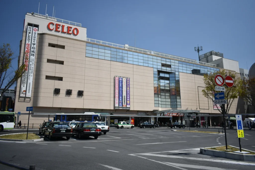
Kofu Station and the Takeda Shingen statue
Where everything starts, and a map entry in its own right — along with the Shingen statue on the traffic island about a minute from the south exit, which is a separate entry. The station straddles the old castle grounds, so the ramparts begin a few minutes from the south exit rather than somewhere across town. The tourist information office inside the station is the practical place to ask whether the printed map is still in stock.
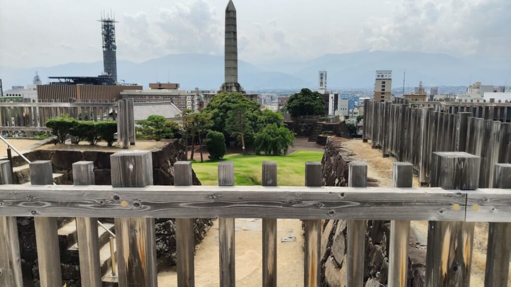
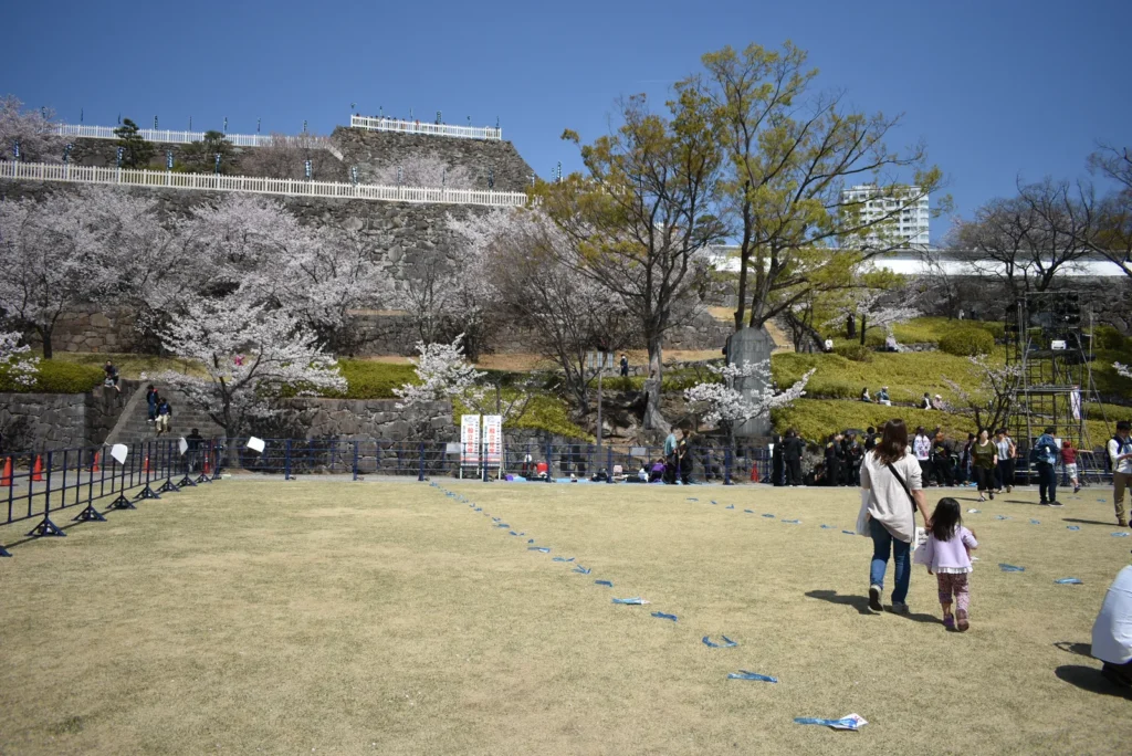
Maizuru Castle Park, the Kofu Castle site
A nationally designated historic site about three minutes on foot from the south exit, by the official map’s own access note. The stone ramparts are original; the buildings on top are later reconstructions. Climb to the upper level and the whole basin opens out, with the Southern Alps on one side and the Misaka range on the other — the single best free view in the city.
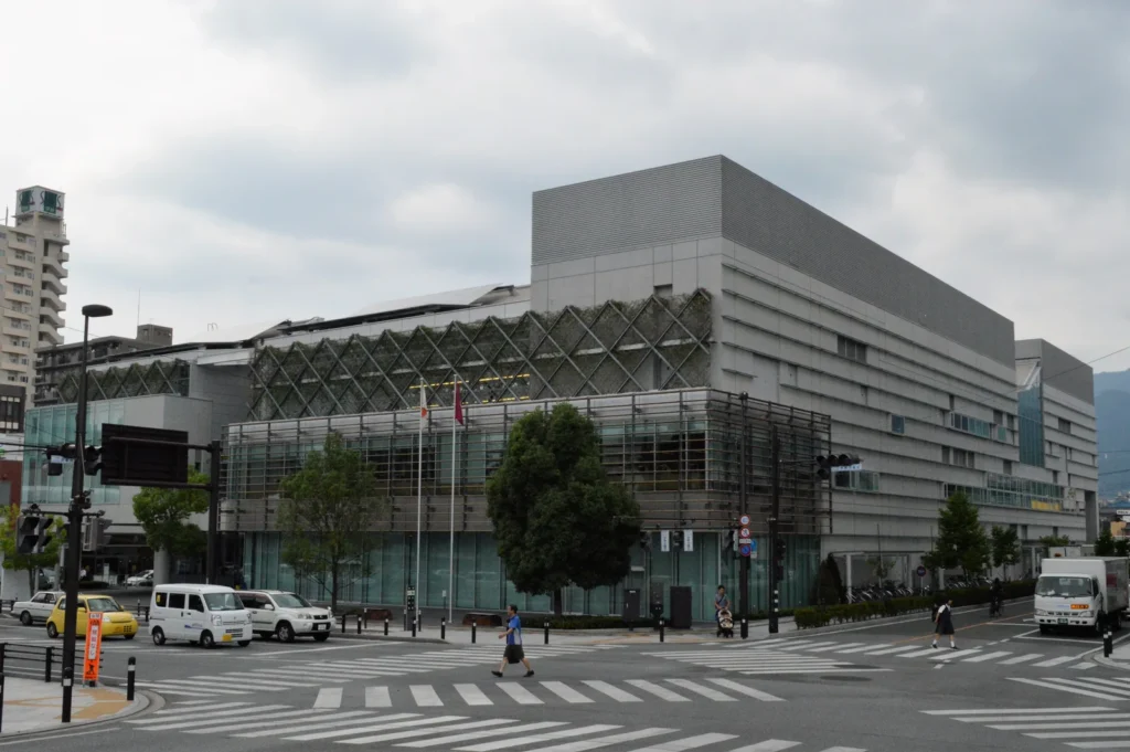
Yamanashi Prefectural Library
On the north side of the station: the library’s own access page gives about three minutes on foot from the north exit along the pedestrian deck, with a covered walkway to the door. Coming from the castle park on the south side, walk back through the station to the north exit first. A glass-fronted public library with a cafe and an open atrium, and a pleasant building to sit in. It is on the map, and it is also a working library: people are studying, and the posted rules on photography apply to you.
Yamanashi Prefectural Science Center
Map spot 26 and the first stop on the official photogenic course: hands-on physics and astronomy exhibits, a planetarium, and a hilltop position with a view back over the city. The catch is the hill. It is about thirty minutes uphill on the nature path from Kofu Station’s north exit by the centre’s own estimate, route buses run only on Saturdays, Sundays, public holidays and Kenmin no Hi, and there are about 200 free parking spaces. Budget the climb as its own half of an afternoon, come on a day the buses run, or drive.
- Hours: 9:30 to 17:00, last admission 16:30. Closed the first, second and third Mondays of each month — the Tuesday instead when that Monday is a public holiday — and 29 December to 1 January.
- Admission: 520 yen adults, 220 yen students, preschool children free. The planetarium is a separate 310 yen or 120 yen per session.
The rest of the Kofu thirteen, and how far they are
Within the walk: Kofu City Hall (about 10 minutes), Orion East (a cafe-bar on the south side of the castle park, 5 to 8 minutes) and the coffee-and-lunch shop Hinata (about 10 minutes), the first stop on the official mega-portion course. Further out: Haruyama Shrine, a small neighbourhood shrine about 25 minutes on foot or 10 by car; the original site of Kainakami Shrine, about 10 minutes on foot from the Science Center car park; Midorigaoka Sports Park, about 15 minutes by bus from the south exit to the Shiobe stop and 5 minutes on foot; the curry house Indo Kitchen, about 15 minutes by car and another mega-portion stop; and the strawberry cafe at the Hijikata orchid and strawberry farm, about 20 minutes by car. The four businesses are businesses first. Check their own hours, and order something.
Hokuto and Kiyosato — the largest cluster on the map
Eleven of the fifty-three are in Hokuto, in the Yatsugatake foothills an hour or so north of Kofu. This is highland country at around 1,200 metres: cooler, brighter, and the part of the prefecture the series drives to when it wants scenery rather than errands. Episode 5 comes up here for ham and ends up eating curry in Kiyosato.
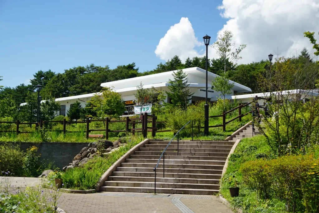
Kiyosato Station
Map spot 04 and the natural base for this cluster: a white station building at 1,275 metres on the JR Koumi Line, with a preserved steam locomotive beside it and the resort village spread out below.
The timetable is the whole constraint. The Koumi Line from Kobuchizawa takes roughly 24 minutes, but services are sparse — on the order of fourteen or fifteen trains a day in each direction — so check it before you plan around it. Moegi no Mura and the ROCK restaurant are about eight minutes on foot; almost everything else in Hokuto is not walkable, which is why this district is the one that really wants a car.
Higashizawa Ohashi and Yatsugatake Kogen Ohashi
Two bridges on the Yatsugatake Kogen Line, and two of the most photographed places in the prefecture. Higashizawa Ohashi (spot 03) is the red arch over the gorge, at its best in late October when the slopes around it turn; there is parking for about twenty cars. Yatsugatake Kogen Ohashi (spot 07) is the long yellow span a few minutes further on, with a viewing platform looking at the Yatsugatake peaks on one side and the Southern Alps on the other. The photograph at the top of this guide was taken there. Both are roadside; neither has a bus stop you can rely on outside the summer and autumn season.
Sunmeadows Kiyosato and the Kiyosato Terrace
Map spot 08 and the last stop on the official photogenic course: a panorama lift up to 1,900 metres, a deck of oversized circular sofas, a cafe stand, and Mount Fuji across the Nobeyama plateau on a clear day.
It is seasonal, because it is a ski resort the rest of the year. The 2026 terrace season ran from 29 April to 3 November, with the lift 9:00 to 16:30 and the last ride up at 16:00; check the dates for your year. The lift fare at the ticket window on the day is 3,000 yen for an adult from junior high school age, 2,400 yen for a primary school child, 2,200 yen for a child of three and over and 500 yen for a dog, with under-threes free and cheaper advance tickets sold online — all of it on the resort’s hours and fares page, which is where to confirm the season dates for your year; the lift is 1,100 metres long and takes about ten minutes. About five minutes by taxi from Kiyosato Station then ten minutes on the lift, or roughly twenty minutes by car from the Nagasaka interchange.
Moegi no Mura and ROCK
Moegi no Mura (spot 09) is a village of craft shops, a music-box museum and gardens, eight minutes on foot from Kiyosato Station. Inside it is ROCK (spot 10), a beer restaurant founded in 1971 whose beef curry has been on the menu for fifty years and which brews Yatsugatake beer in the basement. Between episode 5’s curry stop in Kiyosato and episode 6’s curry hunt, this is the single most on-theme meal on the whole map. Hours run roughly 11:00 to 21:00 outside the summer peak; closing days are announced on the restaurant’s own channels.
The rest of Hokuto
Kiyosato Ham (spot 06), the workshop shop behind the ham that episode 5 drives out for. Makiba Park (spot 02), a prefectural meadow park with sheep and a wide Yatsugatake view, open from late April to early November. Kura Cafe Koji’s at Shichiken (spot 01), a sake brewery in Hakushu with a cafe serving koji-sugar sweets. Kuramoto Yagi’s natural-ice shaved ice at the Hakushu roadside station (spot 11), a stop on the official shaved ice course. Yatsugatake PA (spot 05), the westbound service area on the Chuo Expressway, which is a car-only entry by definition.
Yamanashi City — the fruit and hot-spring hills
A short hop east of Kofu by train, then up. Two of the four spots here are also Laid-Back Camp locations, which makes this the most efficient stretch of the map if you care about both series.
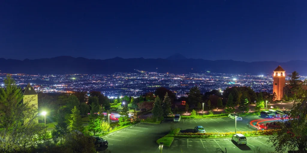
Fuefukigawa Fruit Park
Map spot 42, the third stop on the official photogenic course, and a Laid-Back Camp model location confirmed by Yamanashi Prefecture’s own tourism site — the park where Nadeshiko photographs the night view in episode 5, and where the club stops in episode 4. Orchards, glasshouse domes, a water-play course, restaurants and cafes, and a hillside looking straight down the Kofu basin.
Come for dusk. The night view is certified as one of the New Three Great Night Views of Japan and there is a footbath to sit in while you wait for it, which is the single most pleasant hour on this whole map. The park is free and open; individual facilities inside have their own hours. Yamanashi-shi Station then about seven minutes by taxi or city bus, or about thirty minutes by car from Kofu on the Fruit Line — and work out how you are getting back down before it gets dark.
Hottarakashi Onsen
Map spot 43, a stop on the official gourmet course, and a Laid-Back Camp model location — the prefecture’s tourism site names it as the onsen the club stops at on the way to its first camp, and the official mono map adds that the curry here was introduced in the series. Open-air baths on a hillside above the basin with Mount Fuji across it, in two separate baths, Atchi no Yu and Kotchi no Yu, entered separately.
It opens an hour before sunrise, and that is the whole point of the place. Open year round until 22:00, though the site’s own FAQ gives a different last entry, so confirm on the day. 900 yen for adults and 400 yen for children up to the end of primary school, per bath, with about 280 free parking spaces. About ten minutes by taxi from Yamanashi-shi Station; it is roughly 1.2 km uphill from the fruit park and the prefecture’s own pages describe walking it as hard work.
The other two
PESCA-SHOP / Yamanashi Naito Farm (spot 45), a farm shop standing in its own peach orchard, on the official shaved ice course. The map’s own entry points out that the Kyoho grape shaved ice that appears in the series is a limited-period menu item — a useful reminder that a dish in an episode is not necessarily on the menu the day you turn up. Open 10:00 to 16:00, closed Tuesdays and Wednesdays. Odarumi Pass (spot 44), which the official map calls the highest road pass in Japan at 2,365 metres. Fifteen minutes on a path from the pass reaches the Yume no Teien viewpoint and a very large panorama. It is a serious mountain drive, closed in winter, and not something to attempt casually.
Katsunuma and Koshu — the vineyards
Four spots, all on the wine side of the basin, and the setting for the winery run in episode 4. Katsunuma-Budokyo Station is on the same Chuo Line as Kofu, a little further east than Yamanashi-shi, which makes this the easiest hill cluster to reach without a car.
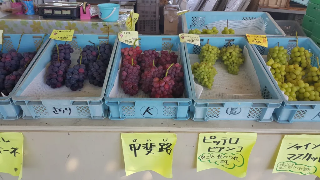
Budo no Oka
Map spot 48 and the sixth stop on the official gourmet course: a hill of vineyards with a wine cave underneath it. The tasting is the draw. The last figure published by the hill was 2,200 yen including tax to taste from more than a hundred Koshu-recommended wines between 9:00 and 17:30, coming and going as you like, with a restaurant and accommodation on site. That price could not be confirmed on 27 October 2026: its own site was returning a service-suspension notice, and the tasting page redirects to it. Treat the figure as the last one published rather than as today’s. A suspended website is not a closed hill, and the listings that quote other prices are not the operator — so check with the hill itself before you build an afternoon around the tasting, and treat the vineyards and the view, which are free, as the reason to come up. About fifteen minutes on foot uphill from Katsunuma-Budokyo Station, or ten minutes by car from the Katsunuma interchange.
Note what is closed. The day-trip hot spring here, Tenku no Yu, map spot 49, closed for renovation on 13 October 2026 and the operator’s notice of 3 October 2026 gives the end of March 2027 as the plan rather than a confirmed reopening. That notice concerns the bath only: the wine cave, the restaurant and the rooms are separate facilities with their own pages.
Katsunuma Tunnel Wine Cave
Map spot 47, and the second stop on the photogenic course. A disused Chuo Line railway tunnel, soot still on the walls, converted into a cellar storing around a million bottles. Part of it can be visited, 9:00 to 16:00, closed over the new year and on inspection days. Eight minutes by bus from Katsunuma-Budokyo Station to the Dainikage Tunnel walking path stop, or seven minutes by car from the interchange.
Wine Glass Kan
Map spot 46, a glassware shop and workshop near the interchange where you can grind a design into a glass and take it away. Free entry, 9:30 to 17:30, open all year. Eight minutes by car from the Katsunuma interchange, and awkward without one.
Fuefuki and Isawa — the sweet-and-onsen side
Four spots on the Kofu side of the vineyards. Isawa-Onsen Station is two stops east of Kofu on the Chuo Line, and the station itself and Tsuchiya are on foot from it; the prefectural museum is about 10 minutes by bus from the station; the Shingen mochi factory is a car or taxi ride.
- Isawa-Onsen Station (spot 50). The gateway to the basin’s largest hot spring resort, with a tourist information desk inside and a free footbath on the forecourt. A sensible place to start or end a day.
- Kikyo Shingen Mochi Factory Theme Park (spot 52). The home of the prefecture’s signature sweet, and the first stop on the official shaved ice course. The self-guided factory tour runs 9:00 to 16:00 and is free; the famous fill-a-bag sale is 220 yen a bag from 9:00 until it sells out, with numbered tickets when it is busy. About a hundred free parking spaces. It sits near the Ichinomiya-Misaka interchange and is hard to reach without a car.
- Tsuchiya (spot 53). A confectioner inside the Itoyanagi inn by Isawa-Onsen Station, descended from a castella cake that came to the town with a bride about seventy years ago. 9:00 to 18:00, closed the first Tuesday. The second stop on the shaved ice course.
- Yamanashi Prefectural Museum (spot 51). The fourth stop on the photogenic course, covering the history of the basin from prehistory to the Takeda clan and after.
West of Kofu — Kai, Showa, Nirasaki and Minami-Alps
Sixteen spots — Kai 5, Showa 3, Nirasaki 4 and Minami-Alps 4 — spread across the flat western half of the basin and up into the mountains behind it. Two are mega-portion restaurants from the official gourmet course (the other two are in Kofu), three are shaved ice stops, and the rest are a mix of station forecourts, viewpoints, parks, a campsite and one skateboard shop.
- Ryuo Station (spot 22), one stop west of Kofu, with a station building designed by Tadao Ando. The forecourt holds two more map entries of its own: the statue of Yamagata Daini (spot 23), an eighteenth-century scholar the town venerates as a god of learning, and Yahata-inu (spot 24), the Kai city mascot — part local taro, part Kai dog — which is there as a face-in-the-hole photo board. Three map entries within a minute of the ticket gates makes this the easiest non-Kofu cluster to reach by train.
- Bremen (spot 20) and Bonchi (spot 21) in Kai, the second and third stops on the official mega-portion course and closer to the train than you might expect: the map puts Bremen about 600 metres, or 8 minutes on foot, from Ryuo Station, and Bonchi about 1.6 km, or 22 minutes. Both are working restaurants. Pick one.
- Nirasaki Heiwa Kannon (spot 15), a white Kannon statue standing above the town on the Shichirigawa bluff, built as a prayer for peace and reached by climbing to Kannonyama Park. About fifteen minutes on foot from Nirasaki Station, or five by taxi; parking for about five cars and no coaches.
- Amariyama (spot 12), a ridge in front of the Southern Alps where the azaleas flower in early summer and the leaves turn in autumn, and where the draw is sunrise over the Kofu basin with Fuji behind it. Below it, Hakuhoso and the Sawaraike campsite (spot 13), cool even in high summer. Nirasaki Station platform (spot 14) is on the map for its own view of Fuji and the Yatsugatake.
- Yashajin Pass (spot 16) in Minami-Alps, a beginner’s mountain viewpoint over the Shirane three peaks, about an hour’s climb from the trailhead by the city tourism association’s own description — and also a Laid-Back Camp location, named by the prefecture’s tourism site as a point on Rin’s route in episode 9. What is seasonal here is the access, not the pass. The forest road from the valley up to the Yashajin trailhead is open all year according to the prefecture, so you can drive to the trailhead car park in any season, snow permitting. The climbing bus from Kofu Station, about 90 minutes, runs only from late June to early November. The road beyond the Yashajin gate towards Hirogawara is closed to private cars even in summer and shuts completely in winter (from 4 November in 2026). A winter climb to the pass is a snow-gear hike, not a stroll.
- Mikado Minami Park (spot 17), Miyoshido (spot 18) and the Minami-pusu shaved ice shop (spot 19), the last two both on the official shaved ice course.
- Aeon Mall Kofu Showa rooftop car park (spot 38), which is on the photogenic course for the view off the roof and is a reminder of what kind of series this is; plus MOSSY’S (spot 39) and the wheat-gluten maker Fu no Okadaya (spot 40) in Showa.
Lake Shibire — Ichikawamisato’s single entry
Lake Shibire sits at 850 metres in a fold of the hills south-west of Kofu, a still circular lake about 1.2 km around with no road to the shore. It is spot 41, the only Ichikawamisato entry on the mono map, and it is also where Laid-Back Camp sets its yakiniku camp in episodes 6 and 7 — the lodge Suimeisou on the shore is named as a model location by Yamanashi Prefecture’s own tourism site.
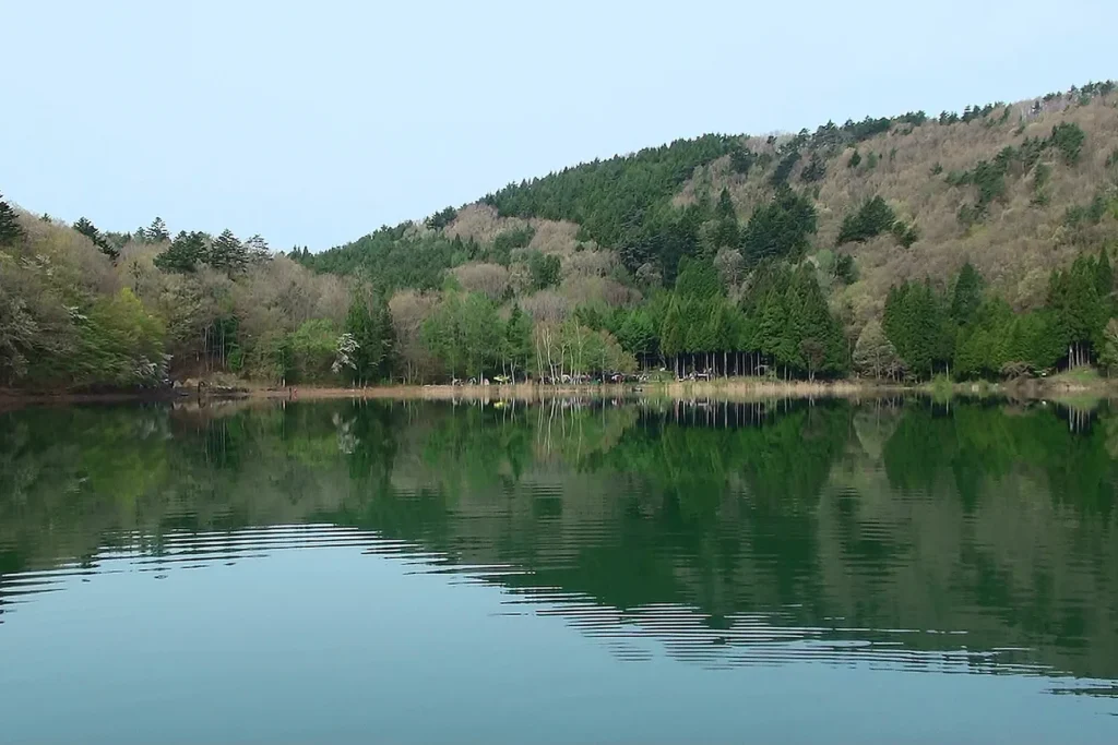
This is the clearest overlap between the two series: one lake, on both official maps. A small, still lake at about 850 metres with forest on every side, roughly 1.2 km around, with the Suimeisou lodge on the shore.
It is the one remote spot that works without a car: a taxi from Ichikawadaimon Station on the Minobu Line takes about thirty minutes. The whole shoreline is campsite land and parking is charged — 400 yen for a car, 200 for a motorcycle, bicycles free. The Laid-Back Camp side of it, including the Fuji-ko pilgrims’ stele on the shore, is in our Laid-Back Camp guide.
How to Get to Kofu and Yamanashi
Kofu is the hub, and everything in this guide is reached from it. The official collaboration site publishes its own approximate journey times, and those are the figures used below; fares and exact timings change, so check with the operator for your date.
From Shinjuku, which is what most people will do
- Limited express, about 1 hour 30 minutes. The Azusa and Kaiji services run down the Chuo Line from Shinjuku to Kofu. These are reserved-seat trains; book ahead for weekend mornings in blossom and autumn seasons.
- Highway bus, about 2 hours. From the Shinjuku Expressway Bus Terminal to Kofu Station. One seat, no changes, and usually cheaper. Vulnerable to traffic on Sunday evenings.
- By car, about 2 hours. The Chuo Expressway to the Kofu-Showa or Kofu-Minami interchange, which is the exit the collaboration site tells you to use.
From the airports
There is no direct rail line from either Tokyo airport to Yamanashi, so every arrival is a connection. Kofu’s own tourism route finder lists Haneda among its departure points, which is the only official airport signal we found; neither airport bus timetables nor fares were confirmed, so none are printed here.
- Haneda. The shorter of the two. Reach Shinjuku first — by Keikyu and JR, by monorail and JR, or by limousine bus — and then take the limited express or the highway bus as above.
- Narita. The same idea with more of it. Narita Express or the Keisei line into Tokyo or Shinjuku, then the Chuo Line.
- Chubu Centrair, if you are coming from the west, connects through Nagoya; the collaboration site gives Nagoya to Kofu as about 3 hours 30 minutes by rail or by car, and about 4 hours 30 minutes by highway bus.
We are not going to give you a door-to-door time from either airport. Immigration, baggage, the walk between terminals and the wait for a connection are the variable parts, and a single headline number would be a guess. Work it out from your own flight with a route planner on the day.
Which arrival suits which plan
- Landing before about 14:00 at Haneda: you can be in Kofu for an early dinner and start the city walk the next morning.
- Landing late, or at Narita: sleep in Tokyo and take the first limited express. Nothing in this guide is worth a midnight arrival in an unfamiliar city.
- Coming from Matsumoto or the Japan Alps side, Kofu is about 1 hour 10 minutes by limited express — this is an easy addition to a Nagano trip.
- Coming up the Minobu Line from Fuji or Shizuoka, allow about 1 hour 40 minutes from Fuji; that is also the line for the Laid-Back Camp side of the prefecture.
Best Way to Get Around
The honest summary: Kofu is a walking city, the basin floor works by train, and the hills want a car. Most of the fifty-three are in the hills.
On foot in Kofu
Around the station, Kofu is flat and close: the Shingen statue about a minute from the south exit, Maizuru Castle Park about three, the prefectural library about three from the north exit, City Hall and Hinata about ten. That is the walk. The other half of Kofu’s thirteen is not: the Science Center is about thirty minutes uphill on the nature path by the centre’s own access page, with route buses only at weekends and on public holidays (the map adds summer-holiday service, and Sundays only in December); Haruyama Shrine is about 25 minutes on foot; Midorigaoka Sports Park is a bus ride; Indo Kitchen and the strawberry cafe are 15 to 20 minutes by car. Treat those as add-ons with their own transport, not as more stops on the walk.
By train along the basin
The Chuo Line runs the length of the Kofu basin and reaches more of the map than people expect:
- Ryuo, one stop west, for the Tadao Ando station building, the two monuments on its forecourt, and Bremen about 8 minutes away on foot.
- Isawa-Onsen, two stops east, for the footbath, the onsen quarter and Tsuchiya, with a bus of about 10 minutes to the prefectural museum.
- Katsunuma-Budokyo, further east on the same line, for Budo no Oka about 15 minutes uphill on foot and the tunnel wine cave by a short bus.
- Yamanashi-shi, for Fuefukigawa Fruit Park and Hottarakashi Onsen — both of which still need a taxi or the city bus from the station.
- Nirasaki, three stops west, for the Peace Kannon, about 15 minutes on foot from the station.
- Kobuchizawa, then the Koumi Line to Kiyosato, about 24 minutes. The Koumi Line is the constraint: roughly fourteen or fifteen trains a day each way, so a missed connection costs you an hour or more.
Buses, and which ones are seasonal
- The Kiyosato Picnic Bus links the Kiyosato spots — including Higashizawa Ohashi — but it is a seasonal service. The 2026 season ran from 25 April to 16 November, daily in July and August and over the late-October to early-November colour, with non-operating days outside those peaks. Check the dates for your year; outside the season this cluster is a taxi or a car.
- The Yashajin Pass climbing bus from Kofu Station takes about 90 minutes and runs only from late June to early November. Outside that window the trailhead is still reachable by car on a road the prefecture keeps open all year.
- Yamanashi City runs a city bus and a demand-responsive service up towards the Fruit Park, about seven minutes from the station. A taxi is the reliable version.
- Shosenkyo Gorge, in the Beyond the Anime section below, has its own bus from Kofu Station.
By car
All three of the official model courses give a driving time from each stop to the next, and the gaps are real: about 40 minutes from Indo Kitchen in Kofu to Hottarakashi Onsen, 65 minutes from Budo no Oka to ROCK in Kiyosato using toll roads, 50 minutes from the prefectural museum to Lake Shibire, 55 minutes from the Nirasaki Kannon to the Kiyosato Terrace using toll roads. If you want more than a third of the map, rent a car. Rental desks are at Kofu Station. Check that your driving documents are valid in Japan before you book, and ask about winter tyres between December and March — the Kiyosato and pass roads are cold.
Planning the days around the transport
- Around Kofu Station: no car. The statue, the castle park, the library, City Hall and Hinata are all within about ten minutes on foot. The Science Center, Haruyama Shrine, Midorigaoka, Indo Kitchen and the strawberry cafe each need a climb, a bus or a taxi.
- Isawa, Katsunuma and Ryuo: train, and the walk from the station is part of the day.
- Fruit Park and Hottarakashi Onsen: train to Yamanashi-shi, then taxi. Budget for two taxi rides and it works.
- Kiyosato: train is possible and pleasant but slow, and only reaches the station, Moegi no Mura and ROCK on foot. Everything else up there needs the seasonal bus, a taxi or a car.
- Lake Shibire, the mega-portion restaurants, Kikyo Shingen Mochi, Odarumi Pass, the Yatsugatake PA: car.
What to Eat in Yamanashi
Eating is not a side activity in this series. One of the three official courses is a mega-portion crawl, another is a shaved ice comparison, and two episodes are built around curry. Yamanashi is a landlocked basin of orchards and vineyards with cold winters, and the food follows from that.
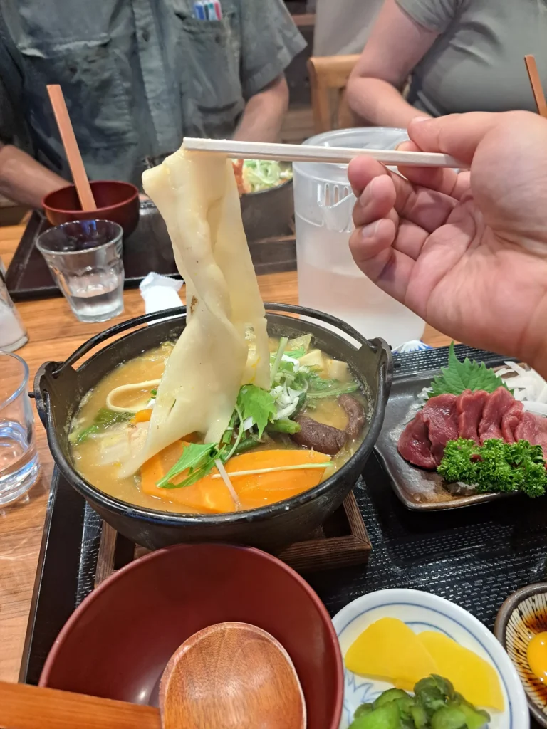
Hoto
The prefecture’s signature dish: flat wheat noodles stewed straight into a miso broth with pumpkin, root vegetables and mushrooms, served in the iron pot it was cooked in. The noodles are not boiled separately, so the broth thickens as it cooks. One pot is comfortably a meal, and because it is cooked to order it takes a while — say so if you have a train.
Curry, which the series takes seriously
Episode 5 ends with curry in Kiyosato and episode 6 is half a curry hunt, and the official map plays along: its own entry for Hottarakashi Onsen points out that the curry there was introduced in the series. Two places are worth knowing:
- ROCK at Moegi no Mura in Kiyosato, where the beef curry has been the house dish since 1971 and the beer is brewed downstairs.
- Indo Kitchen in Kofu, one of the four mega-portion stops on the official gourmet course and a map entry in its own right.
The mega-portion course, and how not to do it
The official gourmet course strings together four large-portion restaurants — Hinata and Indo Kitchen in Kofu, Bremen and Bonchi in Kai — and then sends you to a hot spring and a wine hill. In the series this is a photo rally that visibly defeats four people. Do not attempt all four in a day. Pick one, photograph it honestly, and spend the rest of the day somewhere with a view.
Shaved ice, in season
Episode 11 is called 「山梨かき氷マップ完全制覇」 — conquering the Yamanashi shaved ice map — and one of the three official courses does the same thing across nine stops in five municipalities. Several of them use natural ice. It is a summer activity, and the official entries say so themselves: the Minami-pusu shaved ice shop opens roughly June to September, 11:00 to 15:00, closed on Thursdays and in the rain; Miyoshido’s plum shaved ice and Fu no Okadaya’s fresh-wheat-gluten version are both summer-only; PESCA-SHOP’s Kyoho version is a limited-period menu. Treating the course as a year-round itinerary will end in closed shutters. Check each shop before you drive to it.
Yatsugatake ham, and the highland side
Episode 5 drives up to Hokuto specifically to buy ham, and Kiyosato Ham is on the map for it: Fuji-zakura pork, made in the workshop behind the shop. Pair it with the Yatsugatake beer at ROCK or a picnic at Makiba Park and you have the whole highland half of the series in one afternoon.
Fruit and wine
- Grapes and peaches. Yamanashi is Japan’s largest producer of both. Peaches run from July; grapes carry on into October. Roadside stalls in Katsunuma sell by the variety, and the Shine Muscat and Kaiji on the labels are worth the price difference.
- Wine. Katsunuma is the centre of Japanese winemaking and Koshu is the local white grape. The Budo no Oka cellar is the efficient way to taste widely: the last published figure was 2,200 yen including tax for more than a hundred wines, 9:00 to 17:30, unconfirmed since the hill’s own site went to a suspension notice on 27 October 2026.
- Shingen mochi. Soft rice cakes with soybean flour and black sugar syrup. The factory theme park that makes them is itself on the map.
- Torimotsuni. Chicken offal simmered hard in a sweet soy glaze until it turns glossy — a Kofu dish, found in izakaya and soba shops around the station.
Eating here without wasting the day
- Kofu is a regional city, not a tourist town. Plenty of restaurants close between lunch and dinner, and some close on Sundays.
- If you are driving to the wine hills, the person driving does not taste. Japan has a zero-tolerance drink-driving law and the penalties are severe. Take the train to Katsunuma-Budokyo, or nominate a driver who tastes nothing at all.
- Shaved ice shops are seasonal and several are summer-only.
- Carry cash. Card acceptance in the older shopping streets and at small farm shops is patchy.
Things to Do Beyond the Anime
Kofu was the Takeda clan’s seat and has been the centre of this basin for four hundred years. There is plenty here that has nothing to do with either series.
Maizuru Castle Park through the year
Worth a second visit in season. The ramparts are lined with cherry trees, which makes early April the busiest and best week of the year in the park, and the upper level gives the clearest view of the mountains that enclose the city.
Takeda Shrine
North of the station on the site of the Takeda clan’s residence, dedicated to Takeda Shingen. A quiet shrine in a grove, and the walk up to it from the station passes through the older part of the city.
Shosenkyo Gorge
A gorge of granite cliffs and a waterfall north of Kofu, reached by bus from the station, and one of the best-known scenic walks in the prefecture. Autumn colour is the peak season and the buses are correspondingly full. The crystal workshops along the approach are the reason Kofu became a jewellery town.
Yumura Onsen
A small hot spring quarter on the north-western edge of Kofu, close enough to be a city district rather than a trip. A handful of long-established inns, and the easiest hot spring to reach from the city without a car.
Yamanashi Prefectural Museum
In Fuefuki, and on the official photogenic course. It runs from the prehistory of the basin through the Takeda period to the modern prefecture, and it is a good rainy-afternoon option between Kofu and Katsunuma.
Mount Fuji, from a distance
Kofu does not see Fuji from the city floor, which surprises people. For the view you need height — the Fruit Park hillside, the Kiyosato Terrace, Hottarakashi Onsen — or you need to go south towards the Fuji Five Lakes. If Fuji is the point of your trip, our Laid-Back Camp guide covers that side of the prefecture properly.
What to Bring Home
Most of what is worth buying here is food, and a good deal of it comes from places that are on the map anyway.
- Kikyo Shingen mochi. Soft rice cakes with soybean flour and a sachet of black sugar syrup. Boxed sets travel well. Buying them at the factory theme park — map spot 52 — turns the souvenir into a stop; the fill-a-bag sale is 220 yen and starts at 9:00, and it ends when it sells out.
- Koshu wine. From the Katsunuma wineries or the Budo no Oka shop. Check your airline’s rules first — wine goes in checked baggage.
- Kiyosato ham and sausage. Map spot 06, and the thing episode 5 drives all the way up there for. Buy it on the day you leave and keep it cold.
- Tsuchiya castella. Map spot 53, in the Itoyanagi inn by Isawa-Onsen Station. Seventy years of making the house sweet for a hot spring inn, now sold to anyone.
- Fruit, fresh and preserved. Grapes and peaches in season from the Katsunuma stalls; jam, juice, dried fruit and jelly all year.
- Jewellery and crystal. Kofu has been a jewellery-cutting centre since crystal was quarried in the Shosenkyo hills, and there are still workshops and showrooms in town.
About anime merchandise
- There is no permanent mono shop. Collaboration goods have appeared in limited runs at tourist offices and at events, and when a run sells out it is gone. A collaboration event in Minami-Alps and a wrapped-bus model car were announced in August 2026; neither is a standing attraction.
- The printed pilgrimage map is distributed free in limited quantities at participating locations, and the organisers explicitly prohibit resale or transfer. Take one if you will use it.
- If a shop is on the map, it is a working business first. Buy something if you go in.
Where to Stay
Kofu for the city day and as the hub for everything reachable by train. Add a second base only if you are going up into the hills.
Around Kofu Station
The practical choice. Business hotels cluster on both sides of the station, five to ten minutes on foot, and they are the cheapest reliable option in the city. Plain, almost all with a bath and breakfast, and one minute from the first stop on the walk.
Isawa Onsen
Two stops east of Kofu on the Chuo Line, and the largest hot spring resort in the basin — more inns to choose from than anywhere else here, a station with a footbath outside it, and the right side of town if you are adding Katsunuma the next day.
Yumura Onsen
A short bus or taxi ride north-west of Kofu Station. A small hot spring quarter with long-established inns where the evening meal is part of the stay. Good for one onsen night without a separate journey; less convenient if you plan to be out late in town.
Kiyosato
Worth a night if you are doing the Hokuto cluster properly, and close to essential if you want the Kiyosato Terrace in the morning before the cloud comes in. Moegi no Mura has its own hotel; there are pensions all over the plateau. Remember that the last Koumi Line trains are early.
Budo no Oka
The wine hill at Katsunuma has rooms as well as a cellar and a restaurant, which solves the tasting-and-driving problem neatly: nobody has to drive afterwards. The day-trip bath, Tenku no Yu, is scheduled to be closed for renovation from 13 October 2026 to the end of March 2027; the operator’s notice covers the bath only.
Before you book
- The basin fills for cherry blossom in early April, for the Shingen festival in the same month, for the peach blossom in Fuefuki and for autumn colour in November. Book early for those weeks.
- Kiyosato is a highland resort with a summer season and a ski season; spring and late autumn can be quiet to the point of closure. Check that your inn is open.
- If any day of your plan includes Lake Shibire, the mega-portion restaurants or Kikyo Shingen Mochi, you need a car that day. Check parking at your hotel — some station-side business hotels charge separately and have few spaces.
- Hot spring inns usually have fixed check-in and dinner times. Arriving on a late train is a station hotel evening.
Suggested Itinerary
Fifty-three places across a whole prefecture is a map, not an itinerary. The series is a photography club driving around eating well and looking at things, so the right way to use this guide is to pick one district and do it properly. The full map is below, region by region; this is how the regions differ.
| District | Kofu city | Yamanashi City hills | Katsunuma and Koshu | Hokuto and Kiyosato |
|---|---|---|---|---|
| Spots | Thirteen of the fifty-three | Fruit park and hot springs | Vineyards and wine caves | The largest cluster on the map |
| Car needed | No. Several are minutes from the station | No, with taxis for the last climb | No. The station is at the foot of the hill | Yes, in practice |
| Why go | Castle ramparts, the library, the science centre, and the only walkable half of the map | The night view, the sunrise bath, and two places that are also Laid-Back Camp locations | Tasting from a hundred wines in one afternoon | Alpine scenery at 1,275 m and the terrace at 1,900 m |
| Time | One day | Half a day plus an evening | Half a day | A full day, seasonal |
Four blocks. Take A on its own as a day trip, or stack A with B or C for a weekend, or run the whole thing as D with a car. Each day leaves time to stop and photograph things, which is rather the point.
A — the Kofu day, on foot from the station
- Morning. Start at Kofu Station, which is a map entry. Out of the south exit: the Takeda Shingen statue (about a minute), then Maizuru Castle Park (about three). Climb the ramparts for the view over the basin. Three map entries before you have walked ten minutes.
- Late morning. Orion East on the south side of the castle park and Kofu City Hall are both within about ten minutes of the station. Then back through the station to the north exit and three minutes along the pedestrian deck to the Yamanashi Prefectural Library — sit in it for a while.
- Lunch. Hoto or torimotsuni near the station, or Hinata, about ten minutes on foot and the first stop on the official mega-portion course. Allow an hour; hoto is cooked to order.
- Afternoon, choose one add-on. The Science Center: about thirty minutes uphill on the nature path from the north exit (or the weekend and holiday bus), about ninety minutes inside with a planetarium session, and the original site of Kainakami Shrine about ten minutes on foot from its car park — check the Monday closures. Or a taxi of about 15 minutes to Indo Kitchen for a second, later lunch. Or Haruyama Shrine, about 25 minutes on foot. Trying to do all of them, plus Midorigaoka and the strawberry farm 20 minutes out by car, turns a pleasant day into a schedule.
- Late afternoon. Two stops east to Isawa-Onsen Station for the free footbath on the forecourt and a box of castella from Tsuchiya.
- Evening. Dinner in Kofu, or the bus out to Yumura Onsen.
B — adding Kiyosato and the Yatsugatake foothills
- Early. Chuo Line to Kobuchizawa, then the Koumi Line to Kiyosato, about 24 minutes. Check the return times before you leave the platform — there are only fourteen or fifteen trains a day.
- Morning. Kiyosato Station and the preserved locomotive, then eight minutes on foot to Moegi no Mura for the gardens and the craft workshops.
- Midday. The ROCK beef curry, which has been on that menu since 1971, with a Yatsugatake beer if you are not driving.
- Afternoon. Taxi or the seasonal Picnic Bus out to Higashizawa Ohashi and Yatsugatake Kogen Ohashi for the two bridge viewpoints, then up the Sunmeadows panorama lift to the Kiyosato Terrace at 1,900 metres. Allow a full hour at the top; that is what the sofas are for.
- Before you leave. Kiyosato Ham for something to take home, and Makiba Park if the season is open and you still have light.
- Honest note. Without a car or the seasonal bus, this day realistically covers the station, Moegi no Mura, ROCK and one taxi ride. That is still a good day. Staying the night up here is what makes the rest of it work.
C — adding the fruit, wine and hot-spring hills
- Morning. Chuo Line east to Katsunuma-Budokyo. Walk about fifteen minutes uphill to Budo no Oka. The cellar tasting was last published at 2,200 yen for over a hundred wines from 9:00, but that could not be confirmed on 27 October 2026, so ask the hill before you build the morning around it. If the current price and conditions cannot be confirmed, the tasting is not required: the vineyards and the view over the basin are free either way, so make this a stop for those, or go straight on to the afternoon’s tunnel wine cave. Lunch at the view restaurant. The Tenku no Yu bath is closed for renovation until the end of March 2027 on the current plan, so it is not part of this day.
- Early afternoon. A short bus to the Katsunuma Tunnel Wine Cave, a railway tunnel with a million bottles in it, open 9:00 to 16:00. Buy grapes from a roadside stall on the way back to the station.
- Late afternoon. Back west to Yamanashi-shi, then a taxi up to Fuefukigawa Fruit Park. Sit in the footbath and wait for the lights to come on in the basin — this is one of the New Three Great Night Views of Japan, and it is also the view Nadeshiko photographs in Laid-Back Camp.
- Evening. Dinner in the basin, then back down to Yamanashi-shi or Isawa for the night. Hottarakashi Onsen is ten minutes further up by taxi, but it does not admit anyone who has been drinking, so it does not belong at the end of a tasting day. Take it the next morning instead.
- Better: reverse it. Hottarakashi opens an hour before sunrise, and the operator turns away anyone who has been drinking, so the bath goes first and the cellar afterwards. The dawn bath over the basin and the wine in the afternoon is the version that works, if you can face the taxi.
Combine This Trip with Laid-Back Camp
The two series share an author, and the publisher does not leave this to inference: Houbunsha’s own page for the first volume of mono describes it as a work by afro of Yuru Camp / Laid-Back Camp, and says that the volume includes a pilgrimage collaboration chapter revisiting scenery Laid-Back Camp readers will recognise, with Rin and Nadeshiko glimpsed in the background. The official collaboration site repeats the shared authorship.
On the ground, four places appear in both works. Each is listed on the mono map and named as a Laid-Back Camp model location by Yamanashi Prefecture’s own tourism site:
- Fuefukigawa Fruit Park — mono spot 42; Laid-Back Camp episodes 4 and 5, where the night view is photographed.
- Hottarakashi Onsen — mono spot 43; Laid-Back Camp episodes 4 and 5, the bath on the way to the first camp.
- Lake Shibire and Suimeisou — mono spot 41; Laid-Back Camp episodes 6 and 7, the yakiniku camp.
- Yashajin Pass — mono spot 16; Laid-Back Camp episode 9, a point on Rin’s route south.
Two things are not shared, and this guide does not blur them. Minobu and Lake Motosu are Laid-Back Camp locations on the Yamanashi side that are not on the mono map, and Fumotoppara is not in Yamanashi at all — it is across the border in Fujinomiya, Shizuoka. Laid-Back Camp’s own route crosses both prefectures; mono’s fifty-three are all in Yamanashi. And Kikyo Shingen mochi appears in Laid-Back Camp episode 2 as a sweet eaten in the clubroom — the factory theme park on the mono map is not a Laid-Back Camp location, it just makes the same sweet.
D — the combined trip, three days with a car
- Day 1. Kofu on foot, exactly as in A. Leave the car parked.
- Day 2. Drive east, but in this order: Hottarakashi Onsen first, from an hour before sunrise, then Fuefukigawa Fruit Park, then Katsunuma for the cellar and the tunnel, where the driver tastes nothing. The bath does not admit anyone who has been drinking, so it cannot be the end of a tasting day.
- Day 3. South-west to Lake Shibire, about forty minutes from the Kofu-Minami interchange — the third shared location, and the one Laid-Back Camp gives two whole episodes to. Carry on down the Fuji River valley to Minobu for the Laid-Back Camp side proper.
- Without a car, the same shape works over three days: A, then C by train and taxi, then the Minobu Line south. Lake Shibire becomes a thirty-minute taxi from Ichikawadaimon or comes off the plan. Yashajin Pass is a bus day only between late June and early November; outside that it is a drive to the trailhead and an hour’s walk up.
- Our Laid-Back Camp pilgrimage guide covers the southern half of the prefecture in detail — Lake Shibire from the camping side, Minobu, Lake Motosu and the Fuji views.
Travel Tips & Etiquette
The organisers put their own manners notice on the map. It says that some of the listed places have restricted access, and asks visitors to follow the rules and enjoy themselves. Take that literally — a good third of the fifty-three are private businesses, and several more are ordinary public buildings people are trying to use.
- Most of these places are not attractions. A library, a city hall, a public park, two small shrines, a rooftop car park and a dozen shops and restaurants. Behave the way you would if the series did not exist.
- The library is a library. People are studying in it. Keep your voice down, do not photograph readers, and check the posted rules before taking pictures inside at all.
- Do not photograph people without asking — staff, customers, children in a park.
- At shrines, keep to the visitor paths. Haruyama Shrine and the original site of Kainakami Shrine are neighbourhood shrines in residential areas, not managed sightseeing spots.
- Stay out of schools, private land and private homes. A map entry is not an invitation to go in. Photograph from the public road or not at all.
- If a spot is a business, be a customer. Buying a coffee is the price of standing in the doorway of a cafe that is on the map.
- Lake Shibire is somebody’s campsite. The car park and the whole shore are private land, parking is charged, and people are sleeping there.
- Do not block the pavement or the road. This applies in particular to the station forecourts, the Shingen statue on its traffic island, and the two bridges in Kiyosato, which are live roads with narrow footways.
- Take rubbish with you. Public bins are rare.
- Keep the printed map in circulation. Free, limited, and not to be resold or passed on.
The things that catch people out here
- Drinking and driving. Japan has a zero-tolerance limit and the penalties reach the passengers as well as the driver. If your day includes Budo no Oka, Shichiken or ROCK, go by train or nominate someone who tastes nothing.
- Seasonal everything. The Kiyosato Terrace, the Picnic Bus, Makiba Park, the Yashajin climbing bus, the shaved ice shops and Odarumi Pass all have seasons, and several are shut for half the year. Check each one for your dates.
- Mountain roads in winter. Kiyosato sits above 1,200 metres and the passes close. Ask for winter tyres between December and March.
- Campaigns end. Collaboration events, stamp rallies and limited-period transport come and go. Confirm something is still running before you build a day around it.
- Opening hours change. The official map prints hours and then warns that they may have changed. Check with the facility, not with a guide — including this one.
Plan Your Trip
Five things to settle: how many days, where you sleep, whether you are driving, which season you are in, and which slice of the fifty-three you are actually going to see.
- How long. One day does Kofu properly. Two days adds either Kiyosato or the wine and hot-spring hills. Three days with a car covers the shared Laid-Back Camp locations as well. Trying to do all fifty-three is a driving holiday, not a trip.
- Accommodation. A business hotel at Kofu Station for the walk; Isawa Onsen for a larger choice of inns and a head start on Katsunuma; Yumura for one onsen night inside the city; Kiyosato if you are serious about the Hokuto cluster. Book early for early April and November.
- Transport. Chuo Line limited express from Shinjuku, about 1 hour 30 minutes, or the highway bus, about 2 hours, per the official collaboration site. If you hold a rail pass, confirm it covers the limited express before you plan around it. Rent the car at Kofu Station only for the days that need it.
- Season. April for blossom in the castle park and the peach orchards; summer for the shaved ice course and the highland air; October and early November for the bridges, the vineyards and the Koumi Line; winter for clear Fuji views and a lot of closures.
- What to check in advance. The Science Center’s Monday closures and planetarium timetable; the Kiyosato Terrace season and the Picnic Bus dates; the Koumi Line return times; whether the shaved ice shops are in season; and the Tenku no Yu renovation at Budo no Oka, scheduled from 13 October 2026 to the end of March 2027 — do not plan a bath there in that window.
How this guide was put together
This guide was researched and planned from published sources rather than written up from a visit. Checked on 12 October 2026: the official mono map for all fifty-three spots, their numbers, the photogenic and gourmet courses and the access line for each; Yamanashi Prefecture’s tourism site for the places that are also confirmed Laid-Back Camp model locations; the Yamanashi Prefectural Science Center, Hottarakashi Onsen and Budo no Oka for their own hours and prices; Sunmeadows Kiyosato for the terrace season; and the Budo no Oka operator’s notice of 3 October 2026 for the Tenku no Yu closure that began on 13 October 2026.
One figure is still missing, and it is not missing because of a picture: Hottarakashi’s own FAQ contradicts its opening page on last entry, so the guide says to confirm on the day rather than picking one. The Sunmeadows lift fare was added on 13 October 2026, read from the resort’s own hours-and-fares page, after an earlier version of this guide wrongly described it as published only as an image. Grouping the fifty-three spots into five districts, and the advice to do one district properly, are editorial judgements.
Written and edited by Nick, who runs Anime Routes Japan from Japan. More about Nick, and about how these guides are made, is on the About page.
For Laid-Back Camp’s own route — Minobu and Lake Motosu in southern Yamanashi, Fumotoppara across the border in Fujinomiya, Shizuoka, and the Fuji views, plus Lake Shibire from the camping side — see our Laid-Back Camp pilgrimage guide.
This guide currently contains no affiliate links.