Teasing Master Takagi-san Pilgrimage: Shodoshima, Kagawa
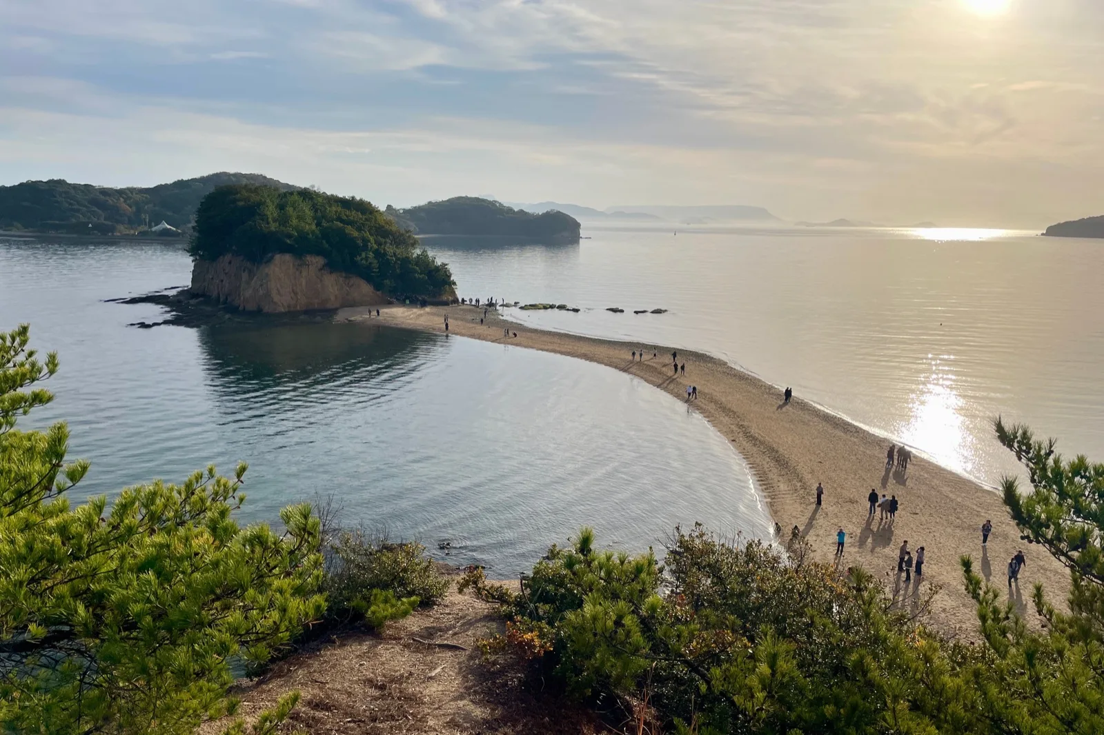
Header photo: Angel Road, the sandbar at Tonosho, seen from above. Photographed in 2023. Photo: おにく, CC0 (resized). Source.
Teasing Master Takagi-san is set in a small seaside town, and the anime’s official location map names the model for it: Tonosho on Shodoshima, the port an hour’s ferry ride from Takamatsu. Planning the trip comes down to three things — the ferry, the tide and how far you are happy to walk. The map’s places in the town centre are within walking distance of Tonosho’s port, the rest are a short bus ride along the coast, and Angel Road, the sandbar in the opening titles, can only be walked when the tide is out. This guide sets out a day trip from Takamatsu and a two-day version with a night on the island, and shows how the tide decides which way round to do them.
Quick Trip Guide
- Series: Teasing Master Takagi-san (からかい上手の高木さん), the manga by Soichiro Yamamoto (Shogakukan). This guide follows the TV anime, which began in 2018
- Destination: Tonosho, on Shodoshima, Kagawa Prefecture — the port, the town around it and Angel Road
- Best Gateway: Takamatsu Port, at the Sunport Takamatsu ferry centre
- Ferry: About 60 minutes, 700 yen one way or 1,330 yen return; the return half is valid for seven days including the day it is issued. The high-speed boat takes about 35 minutes for 1,400 yen, cash only
- Main Base: Takamatsu for a day trip; Tonosho itself for the two-day route
- Getting Around: On foot in Tonosho, with the Olive Bus for Angel Road, the Kashima shore and Olive Park. IC cards such as Suica and ICOCA work on the bus
- Car Needed: No. The ferry carries foot passengers without a booking, and every place in this guide is reached on foot or by bus
- Time Needed: Route A: 6 to 8 hours from Takamatsu Port and back, 4 to 6 of them on the island. Route B: two days with one night in Tonosho. Both are planning estimates, not official durations
- The Tide: Angel Road’s sandbar appears only in the windows of the town’s tide table. Look up your date before you pick a ferry
- Day Trip: Yes, from Takamatsu
- Best For: viewers of the TV anime, an easy island day without a car, and a sandbar walk timed to the tide
Why This Place Matters in Teasing Master Takagi-san
The series is a run of small moments between two classmates — Takagi, who teases, and Nishikata, who keeps trying to get his own back — on the way to school, in the library, on a bridge, at a shrine. The town around them is drawn from Tonosho, which the manga’s author comes from, and the official map pairs each place with the episodes it appears in. The trip is a walk through an ordinary island town rather than a set of attractions, and that is the point of it.
A town the series is modelled on
The anime’s official site describes Tonosho on Shodoshima as the model for the series’ setting, and published the location map in July 2018. Tonosho Town has worked with the series since, and in February 2026 it was chosen for the Anime Tourism Association’s 88 anime places to visit for the seventh year running, the town reports.
TV anime, the anime film and live action
The links in this guide come from the location map for the first TV series. Tonosho Town’s collaboration page lists TV series in 2018 and 2019 and an anime film in 2022, and in 2023 it mentioned a further location map for the third series given out on the island. There is also a live-action drama and a live-action film; they are separate productions with their own locations, and this guide does not use them.
What is on the official map, and what this guide leaves out
The map has ten numbered places. Several of them are residential lanes, a school in use and a bookshop, and those are not places to send visitors, so the routes below keep to public streets, a library seen from outside, a bridge, two shrines and the sandbar. The town landmarks the map marks without a number — the Dofuchi Strait and Meiro-no-machi, the maze of lanes around Saikoji temple — are on the same walk and are included as town sights, not as scenes. Neither the map nor any anime image is reproduced here.
The ten places on the official map, and how this guide treats them
- 1 Fuchizaki lanes (渕崎の路地; opening, episodes 5 and 8) — residential lanes. Not a stop in this guide.
- 2 Tonosho Town Library (土庄町立図書館; episode 5) — seen from outside, on the walk.
- 3 Yahata Bridge (八幡橋; opening, episode 8) — on the walk, about five minutes from the library by the map’s own note.
- 4 Tonosho Junior High School (土庄中学校; episode 1 and many others) — a school in use. Not a stop, no pin; the map’s view of it from the approach to Tomioka Hachiman Shrine is covered below.
- 5 BOOKS Kotobuki (episode 5) — a bookshop. Its current hours were not confirmed, so it is left out.
- 6 Angel Road (opening only) — the sandbar, timed to the tide.
- 7 Kashima seafront and 8 Kashima Myojin Shrine (鹿島明神社; opening, episodes 5, 8 and 10) — a short bus ride west of Angel Road, for Route B or a long day.
- 9 Yanagi tunnel and 10 Yanagi school road (opening, episodes 1, 6 and 8) — a road tunnel and a road further west along the coast. Not stops in this guide.
Anime Pilgrimage Spots
Everything in Tonosho itself is in a rough triangle between the port, the town centre by the Dofuchi Strait and Angel Road, close enough to walk. Kashima is a few stops west on the bus. The order you take them in depends on the tide, which is covered with Angel Road below and in the itineraries.
Please respect local rules and manners at every location, and follow signs and staff guidance.
Where these places are
The map shows the places below and how far apart they are. It is drawn with OpenStreetMap: opening it loads map images from openstreetmap.org. The list works without it. Seven rows carry an official name or address rather than a published position, so they have a Google Maps link but no pin. Homes, the school and the bookshop on the anime map are not listed.
The map could not be loaded. The places are listed below, with their names and a link to each on Google Maps.
- Anime-related places
- Station or transport
- Nearby sight
The 11 places in this guide, 4 of them on the map
- 1Tonosho Port土庄港Published position for the port · ferries, buses, Tonosho BASE upstairs in the port officeIn this guideOpen in Google Maps
- 2Bettei Ginshiro別邸 銀四郎Address only: Kō 5165-102, about five minutes from the port · closed on irregular daysIn this guideOpen in Google Maps
- 3Dofuchi Strait土渕海峡Name search · the narrowest point is by the town officeIn this guideOpen in Google Maps
- 4Tonosho Town Library (Hontopia)土庄町立図書館(ほんとぴあ)Name search · seen from outsideIn this guideOpen in Google Maps
- 5Yahata Bridge八幡橋Name search · by the Yahatabashi-mae bus stopIn this guideOpen in Google Maps
- 6Tomioka Hachiman Shrine富丘八幡神社Top of Tomioka hill · optional climbIn this guideOpen in Google Maps
- 7Meiro-no-machi迷路のまちName search · residential lanesIn this guideOpen in Google Maps
- 8Saikoji西光寺Name search · temple in Meiro-no-machiIn this guideOpen in Google Maps
- 9Angel RoadエンジェルロードThe sandbar · walkable only in the tide windowsIn this guideOpen in Google Maps
- 10Kashima Myojin Shrine鹿島明神社Name search · Kashima, a few minutes west of Angel Road by busIn this guideOpen in Google Maps
- 11Shodoshima Olive Park道の駅 小豆島オリーブ公園Shodoshima town · Route B, optionalIn this guideOpen in Google Maps
Map data © OpenStreetMap contributors, ODbL. Positions were checked on 16 October 2026 against the source recorded for each place; the port pin is the published position for the port as a whole.
Angel Road and the tide
Angel Road (エンジェルロード) is a sandbar that appears and disappears with the tide, linking a small island by the shore, Benten-jima, to the islets beyond it. It is in the opening titles of the TV series, where the two walk across it hand in hand. Above it on Benten-jima is the Promise Hill lookout (約束の丘展望台), the town says, which is the place to see the whole sandbar from above.
Whether you can walk it depends on the day. The town’s 2026 tide table gives, for every date, the predicted windows when the sandbar appears — usually two a day, most of them about six hours long, and one of them often in the night or the early morning. The table says weather and tide levels can shift them, and it recommends the start or the end of a window, when the sand is just appearing or disappearing, rather than the lowest tide. The town’s own websites also show the windows for a chosen date.
- A prediction is not a safety guarantee. Go by what the water is doing on the day, and be back on the shore well before the window closes.
- The sandbar is not a way onto the islands. The 2026 table says you may walk only as far as the near side of Nakayoshima; landing on Nakayoshima and Koyoshima is prohibited for safety, and Oyoshima is the Kobe YMCA’s outdoor activity centre, closed to visitors without permission. The town’s page adds that Nakayoshima is private land.
- The 9:00 to 16:30 hours on the town’s page are those of the information centre and shop by the shore, which move a little with the low tide. They are not the times when the sandbar can be crossed.
- Getting there: about 30 minutes on foot from Tonosho Port, about 12 minutes from the Tonosho-honmachi (土庄本町) bus stop, or about 3 minutes from the Kokusai Hotel (Angel Road-mae) stop, by the town’s map.
Tonosho Town Library and Yahata Bridge
Two of the map’s places sit in the town centre near the town office, across the Dofuchi Strait from the port side. Tonosho Town Library, nicknamed Hontopia (ほんとぴあ), is where the pair study for a test in episode 5; the map notes that the inside, not only the entrance, is drawn faithfully. It is a working public library, so look at it from outside, and if you go in, go in to use it and follow its rules on photography.
Yahata Bridge (八幡橋, Yahatabashi) appears in the opening and in episode 8, and the map puts it about five minutes on foot from the library and describes it as the local children’s route to school. Cross it as a pedestrian, keep to the footway and leave room for anyone walking to or from school.
Tomioka Hachiman Shrine
The map’s entry for the junior high school uses a view of it from the approach to Tomioka Hachiman Shrine (富丘八幡神社), on the top of Tomioka hill to the east of the town centre. The school itself is in use and is not part of this guide. The shrine is a place of worship with views across the town and the sea, so go for the shrine and the view, and do not photograph the school grounds or anyone in them. Because it means a climb, the routes below make it optional. By bus, use the Futagoura (双子浦) stop on the Sakate and Tanoura lines.
Kashima Myojin Shrine and the Kashima seafront
West of Angel Road along the coast is the Kashima district, with two of the map’s places: the seafront road the pair run along in episode 8, and Kashima Myojin Shrine (鹿島明神社), which the map says has more cuts in the series than anywhere else, including episode 10, where the two compare heights in the grounds. The shrine is close to the seafront. It is a few minutes from Angel Road by bus — see Best Way to Get Around — and fits Route B’s second morning, or Route A if the tide gives you time.
Dofuchi Strait, Meiro-no-machi and Saikoji
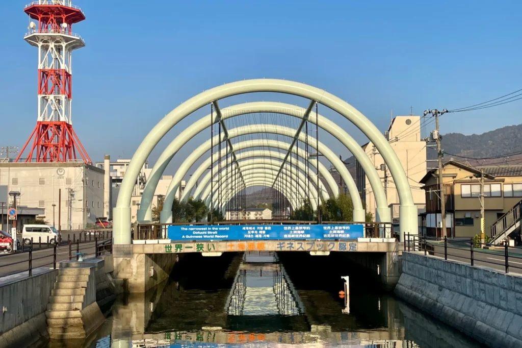
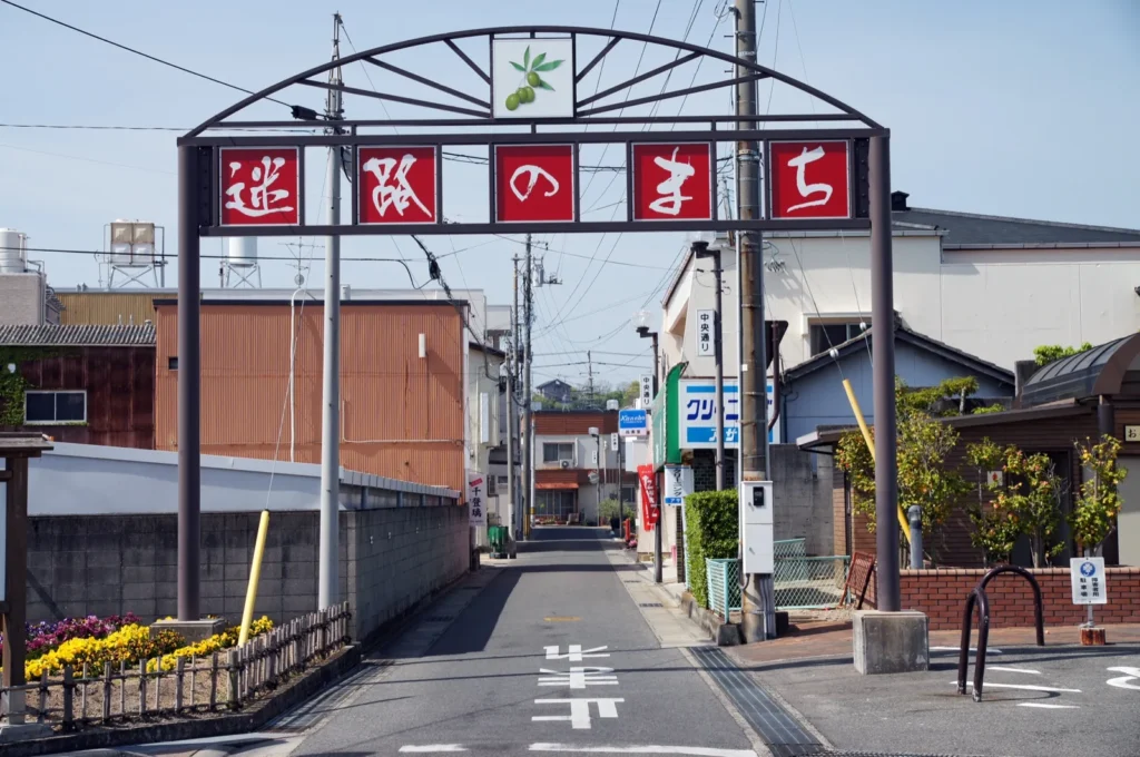
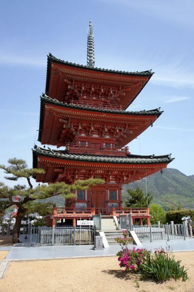
These three are not numbered places on the anime map, but the map marks the strait and Meiro-no-machi as landmarks, and the walk between the port and Angel Road passes all of them. The Dofuchi Strait (土渕海峡) is the narrow channel that divides the town; Guinness World Records recognises its narrowest point, by the town office, as the world’s narrowest strait. Meiro-no-machi (迷路のまち), “the maze town”, is the tangle of lanes south of it, and in it is Saikoji (西光寺), a temple of the Shodoshima pilgrimage with a three-storey pagoda. People live in these lanes: walk them quietly and keep your camera on the lanes, not the houses.
How to Get There
Tonosho is reached by sea. From Takamatsu, Shodoshima Ferry runs two services to Tonosho Port, the car ferry and the high-speed boat; the ferry leaves from the Shodoshima ferry centre at Sunport Takamatsu. The fares below are adult one-way fares unless stated.
The ferry from Takamatsu
- About 60 minutes, 700 yen one way, 1,330 yen return, from the operator’s route page. The return half is valid for seven days including the day it is issued, so the same ticket covers Route B.
- No booking for foot passengers. Only vehicles can be booked; passengers buy a ticket at the port on the day and board first come, first served. Cards are accepted for the ferry since March 2026.
- Two sailings are not for passengers on weekdays. The 15:10 from Takamatsu and the 19:30 from Tonosho carry dangerous goods on weekdays, and also on the public holidays the operator lists for 2026–27. Do not build a plan around either.
- Departures: on the current timetable the ferry runs about once an hour in each direction through the day. From Takamatsu, the 8:02, 9:00 and 10:00 suit a day trip. From Tonosho, the last sailing is the 20:10; the 19:30 before it is not for passengers on weekdays.
- The Takagi-san ferry. One of the route’s three wrapped ships carries the series’ artwork, the operator’s page shows, but maintenance and rostering change which ship sails when. If you want that ship, ask at the port; the plan below works whichever ship you get.
The high-speed boat
The high-speed boat takes about 35 minutes and costs 1,400 yen one way, or 2,660 yen return, on its route page. It has run a reduced timetable of eight sailings a day in each direction since 16 May 2026, the operator says, and it takes cash only. It is useful for an early start or a late return, but the routes in this guide are timed on the ferry.
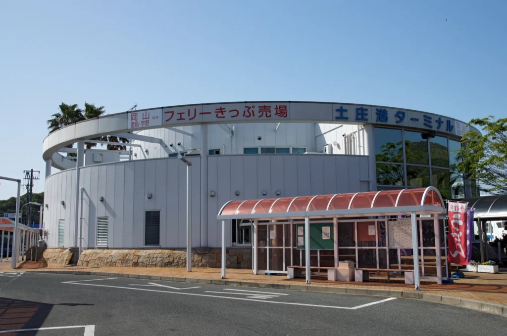
Arriving at Tonosho Port
Tonosho Port is where most Olive Bus routes start and where the walk begins. Tonosho BASE (とのしょうBASE), the town’s Takagi-san corner, is on the second floor of the port office, Kagawa Prefecture’s harbour sheet notes. The town’s collaboration page lists a life-size standee of the characters, the plaque for the Anime Tourism Association’s 88 places, and goshuin, with the space open from 8:30 to 16:30. That page dates from 2023; no notice of a closure was on the town’s site on the day this guide was checked, but ask at the port if it matters to you.
Best Way to Get Around
On foot in Tonosho
The town is walkable. The town’s Angel Road map gives about 30 minutes on foot from the port to Angel Road, and about 12 minutes from the Tonosho-honmachi bus stop, the stop for Meiro-no-machi. The prefecture’s harbour sheet puts the Dofuchi Strait about 1.4 kilometres from the port. The anime map puts the library and Yahata Bridge about five minutes apart. Put together, a loop from the port through the town centre, Meiro-no-machi and Angel Road is a few kilometres in all, with the climb to Tomioka Hachiman Shrine as an optional extra.
The Olive Bus
Shodoshima Olive Bus runs most of its routes from Tonosho Port, on a timetable revised on 1 April 2026. Two lines matter for this guide, and both stop at Kokusai Hotel (Angel Road-mae) (国際ホテル(エンジェルロード前)), three minutes from the sandbar.
- Port to Angel Road: the Tanoura Eigamura line at 10:10, 12:20, 13:50 and 16:25, about 11 minutes; the Nishiura line’s eastbound loop at 9:20, 13:05 and 16:40, about 13 minutes. Both are 200 yen. The Nishiura westbound loop, at 7:40, 11:15 and 14:40, goes the long way round by Kashima and costs 500 yen.
- Angel Road to the port: the Tanoura line at 7:58, 13:00, 15:23, 16:58 and 18:36, about 11 minutes; the Nishiura westbound loop at 8:01, 11:36 and 15:01, about 13 minutes. Both are 200 yen.
- Kashima: the eastbound Nishiura loop continues from Angel Road to the Kashima stop in about five minutes (9:33, 13:18, 16:53); the Tanoura line reaches Kashima-naka (鹿島中) about six minutes from the port and comes back from it at 8:03, 13:05, 15:28, 17:03 and 18:41.
- Paying: cash, or an IC card — Suica, ICOCA, PASMO and the other national cards have been accepted on every Olive Bus line since October 2021. Fares are on the operator’s fare charts.
- The one-day ticket is 1,600 yen for adults, the operator says. Route A uses the bus once or twice at 200 yen. On Route B, a round trip to Olive Park is 1,000 yen in single fares and each ride within Tonosho is 200 yen, so add up the day’s rides before you buy one.
Some Nishiura line journeys do not run at weekends, on holidays, from 13 to 15 August or from 29 December to 3 January. Check the timetable for the day before you count on one.
Car and bicycle
A car is not needed for anything in this guide. Hire cars and hire bikes are available near the port, the prefecture’s harbour sheet notes, but the walk and the two bus lines cover the routes below.
What to Eat and Drink
Hand-pulled somen by the port
Shodoshima is known for hand-pulled somen noodles, a craft the island has kept for about four centuries, according to Ginshiro, a somen maker based by Tonosho Port. Its restaurant, Bettei Ginshiro (別邸 銀四郎), is about five minutes on foot from the port, its own page says, and serves fresh (nama) somen, its own premium noodles, olive and black-sesame somen and warm nyumen. On a day that starts and ends at the port, it is the lunch stop on the way.
- Hours: 10:00 to 17:00, last order 16:00, opening at 11:00 on Sundays.
- Closed: on irregular days. Its calendar for October and November 2026 marks several Saturdays and Sundays as closed, so check it for your date. The shop that sells the noodles keeps different days from the restaurant.
If it is closed
The day still works. Kagawa Prefecture’s harbour sheet counts more than seven places to eat within 500 metres of the port pier, so plan lunch around the port rather than around one restaurant. Near Angel Road, the information centre has a shop; it is not a restaurant.
Beyond the Anime
Shodoshima Olive Park
Olive Park (道の駅 小豆島オリーブ公園) is a roadside station on a low hill above the sea, with about 2,000 olive trees, an Olive Memorial Hall, a Greek windmill and a herb garden, the park says. It has nothing to do with the series, and it is in the neighbouring town of Shodoshima rather than Tonosho, so it is here as Route B’s optional afternoon.
- Getting there: the Olive Koen-guchi (オリーブ公園口) stop is about 30 minutes from Tonosho Port on the Sakate line (for example 9:40, 11:30 and 13:00) and the Tanoura Eigamura line (10:10, 12:20 and 13:50), 500 yen each way. The park’s own pages give about 7 minutes on foot from the stop.
- Coming back: buses for Tonosho Port leave Olive Koen-guchi on the Sakate line at 12:11, 13:05, 14:20, 15:41 and 17:31 and on the Tanoura line at 12:36, 15:01, 16:36 and 18:14, arriving about half an hour later.
- Hours: the roadside station is open from 8:30 to 17:00 every day. Its restaurant, hot spring and other facilities keep their own hours, which this guide did not check.
Souvenirs
At Angel Road
The shop in the information centre by the sandbar sells its own postcards and stamps for the Angel’s Post (天使のポスト), a postbox by the shore whose mail is cancelled with a postmark of the island’s scenery, the town says.
Somen and olive oil
Hand-pulled somen and olive oil are both made on the island and both keep well for the journey home. Ginshiro’s noodle shop and its restaurant keep different days, so do not assume one is open because the other is.
Series goods
In 2023 the town listed collaboration goods sold at the port, Angel Road and a few shops — badges, clear files, olive oil and somen with the characters on the label. What is stocked changes, and none of it was checked as on sale for this guide.
Where to Stay
This guide names no hotels and gives no prices. The decision is whether to sleep in Takamatsu or on the island, and the tide is what decides it.
Takamatsu, for the day trip
Route A starts and ends at Takamatsu Port, so a night in Takamatsu before and after works as long as one of the day’s tide windows falls between a morning ferry and an afternoon one.
Tonosho, for Route B
A night in Tonosho gives you two days of windows instead of one, and lets you use an early-morning or evening window that a day trip cannot reach. The prefecture’s harbour sheet counts more than eight places to stay within 500 metres of the port pier. Staying near the port keeps the ferry and the start of most bus lines on your doorstep.
Suggested Itinerary
Route A is a day trip from Takamatsu Port. Route B adds a night in Tonosho, which gives you a second set of tide windows and time for the Kashima shrine or Olive Park. In both, the tide comes first: look up the date in the town’s tide table, then choose the ferries, then the order of the walk.
| Which route | A — the day trip | B — two days, one night in Tonosho |
|---|---|---|
| Time | 6 to 8 hours from Takamatsu Port and back, 4 to 6 of them on the island; a planning estimate with lunch and the waits | Two days, with Angel Road in whichever of the two days’ windows suits you best |
| What you do | Tonosho BASE, the Dofuchi Strait, the library and Yahata Bridge, Meiro-no-machi and Saikoji, and Angel Road | All of A, split between the two days, plus Kashima Myojin Shrine, Tomioka Hachiman Shrine or Olive Park |
| Transport | Ferry both ways, walking, and one bus between Angel Road and the port | The same ferry ticket, walking, and the bus for Kashima and Olive Park |
| Fares, per adult | 1,330 yen ferry return, plus 200 yen for each bus ride: about 1,530 to 1,730 yen | 1,330 yen ferry return, plus 200 yen for each bus ride in Tonosho and 1,000 yen for the Olive Park round trip; the room is extra |
| Book or check first | The tide window for the date; the ferry timetable; Bettei Ginshiro’s calendar if you want lunch there | The same, plus your room, and the last bus back from Olive Park |
| What decides it | A tide window between a morning ferry and an afternoon one | A window that falls early or late, or wanting the places the day trip cannot fit |
A — the day trip
Plan on four to six hours on the island: a morning ferry out, and a ferry back in the afternoon. Then let the tide window decide which end of Tonosho you start at. The ferry and bus times below are examples from the current timetables.
If the window is in the morning or around midday — Angel Road first:
- Ferry to Tonosho: the 8:02 or the 9:00, arriving an hour later.
- Bus to Kokusai Hotel (Angel Road-mae) — the 9:20 Nishiura eastbound after the 8:02 ferry, or the 10:10 Tanoura line after the 9:00 — or walk about 30 minutes. Cross the sandbar, climb Promise Hill for the view, and be off the sand well before the window closes.
- Walk north into Meiro-no-machi and Saikoji, then on to the Dofuchi Strait, the library and Yahata Bridge.
- Walk back to the port, about 1.4 kilometres from the strait, for lunch and Tonosho BASE.
- Ferry back on the 14:45, or the 15:45 if you came over on the 9:00. Either keeps the day within about eight hours from Takamatsu Port and back.
If the window is in the afternoon — the town first:
- Ferry to Tonosho: the 10:00, arriving at 11:00.
- Tonosho BASE, then lunch near the port, Bettei Ginshiro if it is open that day.
- Walk to the Dofuchi Strait, the library and Yahata Bridge, then south through Meiro-no-machi and Saikoji.
- Angel Road, about 12 minutes on foot from the Tonosho-honmachi stop, timed to the start of the window.
- Bus back to the port from Kokusai Hotel (Angel Road-mae) — the 15:23 Tanoura line, at the port 11 minutes later — and the 16:30 ferry, back in Takamatsu at 17:30.
If the day’s only daylight window falls before the first useful ferry or after the last, the day trip still works for the town and the view from Promise Hill, but not for walking the sandbar. That is the case for Route B.
B — two days, with one night in Tonosho
Split Route A across the two days by tide and daylight, and use the time it frees up for the places the day trip cannot fit.
- Day 1: ferry in, Tonosho BASE and lunch by the port, the town walk, and Angel Road if a window falls in the afternoon or early evening while it is still light.
- Day 2, morning: Angel Road in the morning window if you missed it, then the Nishiura bus on from Angel Road to Kashima, about five minutes, for Kashima Myojin Shrine and the seafront. Or take the Sakate line to Futagoura for Tomioka Hachiman Shrine.
- Day 2, afternoon, optional: Olive Park, about 30 minutes by bus from the port. Leave time for the walk back to the stop and a bus that gets you to the port before your ferry — the Sakate line’s 15:41 from Olive Koen-guchi reaches the port at 16:12, in time for the 16:30.
- Ferry back on the return half of your ticket.
Choosing the order: tide, ferry and daylight
- Start with the tide table, not the ferry timetable. Pick the window you want, then the ferries either side of it.
- Use the window, not its edge. The town recommends the start or the end of a window for the view; for walking across, give yourself time on both sides and come back before the sea does.
- Leave out night windows. A window that falls after dark is one to skip, whichever route you are on.
- Weather wins. The table says wind and tide levels can move the times. If the sand is not there when the table says it should be, it is not there.
Travel Tips and Etiquette
At Angel Road
- Stay on the sandbar. You may walk only as far as the near side of Nakayoshima; the islands themselves are closed to visitors, the town says.
- Watch the water, not only the clock. The tide table is a prediction. Turn back early rather than late.
- Leave the rocks and the sea life alone, and take everything you brought back with you.
In the town: homes, a school and two shrines
- The lanes of Fuchizaki and Meiro-no-machi are people’s streets. Walk them quietly, keep to the lanes, and photograph the streets rather than houses, windows or residents.
- The junior high school is a school in use. It is not part of this guide. Do not enter it, wait outside it or photograph pupils, from the shrine or anywhere else.
- The shrines are places of worship. At Kashima Myojin and Tomioka Hachiman, keep to the paths, do not stand in front of the hall while someone is praying, and follow any notices about photography.
- The library is a working library. If you go in, go in to use it, and follow its rules.
Ferries and buses
- Foot passengers cannot book the ferry. Buy at the port on the day; on busy days, arrive in good time.
- The high-speed boat takes cash only; the ferry takes cards as well.
- Buses run every hour or two, not every few minutes. Note the time of the bus you need back before you set off, and check the timetable for weekend and holiday changes.
Plan Your Trip
Do this first
- Look up your date in the 2026 tide table and note the daylight windows.
- Choose A or B from where those windows fall, then the ferries on the operator’s timetable — leaving out the weekday 15:10 from Takamatsu and 19:30 from Tonosho, and checking the holiday list.
- For lunch at Bettei Ginshiro, check its calendar for the day.
- For Route B, book your room, and note the last bus you need from Kashima or Olive Park.
Combine it with another guide
This is the only Shikoku guide on this site so far, so none is suggested as a pairing. Every published guide is listed on All published guides, and by region on Destinations.
How this guide was put together
This guide was researched and planned from published sources rather than written up from a visit. Checked on 16 October 2026: the TV anime’s official location map of 2018 for the places and episodes; Tonosho Town for its collaboration page, its 2026 note on the Anime Tourism Association’s 88 places, the Angel Road page and the 2026 tide table and map; Kagawa Prefecture’s harbour sheet for Tonosho Port; Shodoshima Ferry for the ferry and high-speed boat timetables, fares, payment and the 2026–27 dangerous-goods sailings; Shodoshima Olive Bus for the timetables of 1 April 2026, the fare charts, the one-day ticket and IC cards; Olive Park for its hours and the walk from the stop; and Ginshiro and Bettei Ginshiro for the restaurant’s hours, menu and calendar.
What is an estimate, and what could not be confirmed. The 6-to-8-hour and 4-to-6-hour figures and the walking loop are editorial planning estimates built from the published times, not official durations. The tide windows are the town’s predictions and can shift with the weather. Several places on the map, including the library, Yahata Bridge, Kashima Myojin Shrine and the Dofuchi Strait, have no published position that could be confirmed, so the map lists them by name or address, without a pin. The climb to Tomioka Hachiman Shrine was not measured, Tonosho BASE’s opening hours come from a town page of 2023, and the opening hours of the bookshop on the anime map were not checked.
Written and edited by Nick, who runs Anime Routes Japan from Japan. More about Nick, and about how these guides are made, is on the About page.
Ferry and bus timetables, fares and opening hours change. Confirm the ones your day depends on before you travel, and check the tide table, the ferry operator’s notices and the weather on the day you are going.
This guide currently contains no affiliate links.